The Geographical Information System (GIS) is a framework to collect, store, manage, manipulate, analyse and visualise spatial data. GIS enables to store information in layers and retrieve data to identify unique patterns, solve complex problems, automate processes and build decision support systems. The GIS has the potential to be used in virtually every field. The application of GIS includes urban planning, transportation planning, environmental risk analysis, climate change, flood forecasting and damage estimation, disaster management and mitigation, emergency response, hydro informatics, irrigation water management, reservoir site selection, wetlands mapping, natural resources management, wildlife management, landslide hazard zonation, soil mapping, mineral exploration, modeling renewable energy, agriculture, land information system, public health, waste management, crime analysis and utilities mapping. At NESPAK, the GIS Sector continues to grow exponentially in the engineering and environmental domains.
NESPAK is the pioneer in the GIS Sector in Pakistan and its industry leadership extends over three decades. The Company's vast experience in diverse disciplines has increased its portfolio of GIS projects manifold. So far, more than 45 projects have been undertaken in this sector for local and international clients in addition to providing in-house services for the Company. NESPAK possesses a strong team of GIS experts having excellent technical knowledge and broad experience to ensure successful and timely completion of projects. NESPAK scope of services and experience in the GIS Sector are given below:
Identification of crop types, development of Normalised Difference Vegetation Indexes (NDVIs), generation of NDVI time-series using Fourier components (magnitude and phase), calculation of evapotranspiration and calculation of crop water requirements.
Production of extremely high resolution Ortho-mosaics (less than 10cm), Digital Surface Models (DSM) and Digital Terrain Models (DTM) from Unmanned Aerial Vehicle (UAV) or Drone imaging. Geo rectification by state-of-the-art Differential Global Positioning Systems (DGPS) for survey grade accuracy results.
Aerial triangulation, stereo compilation, bundle block adjustments, digital surface modelling, digital terrain modeling, ortho-rectification, ortho-mosaicking and feature collection (topographic/planimetric maps).
Information extraction from passive and active remotely sensed data (e.g., multi-spectral radiometer, Radar, Lidar), digital image processing, pattern recognition, automated classification of land covers, supervised classification, unsupervised classification, Geographic Object-based Image Analysis (GEOBIA) and change detection.
Development of browser-based GIS application on both Environmental Systems Research Institute (ESRI) and open source platform. Online spatial querying, overlay and buffer analysis and other geo-processing tasks. Dynamic development of thematic maps, based on the outputs of hydrological and hydraulic models.
Development of geo database consisting of thematic map layers e.g., land use, soils, elevation, geology, slope, watersheds, floodplain map layers and their integration with hydrologic, groundwater, evapotranspiration, watershed and river flow models.
GIS data analysis includes querying, reclassification, retrieval, map generalisation, map abstraction, map sheet manipulations, buffer generation, polygon overlay and dissolve, measurements, digital terrain analysis (hydrology, topography etc.), cut/fill volume calculations, network analysis and overlay analysis.
Data collection through field surveys, topographic survey, etc., being applied to all types of features such as roads, rivers, dams.
Map production as perESRI cartographic standards
NESPAK offers a broad spectrum of GIS services in near real-time monitoring of flood, reservoirs, crop conditions, forest disturbances etc, using very high resolution satellite imagery, extremely high resolution digital surface models produced from drone imaging. Development of Web GIS applications and its integration with engineering models and customised GIS applications as per client requirements. To date, NESPAK has developed GIS database and models for urban development, utilities mapping, flood forecasting, watershed management, irrigation and dam engineering.
NESPAK has provided extensive GIS services for 52 projects in the Water Sector. Key projects include National Flood Protection Plan-IV, Water Resources Management Information System (WRMIS), Indus Basin Model Revised (IBMR), Neelum Jhelum Hydropower Project, Greater Thal Canal Project, Alborz Integrated Land and Water Management. Development of GIS/MIS Centre and Decision Support System to Enhance Capacity of Indus River System Authority (IRSA-I), GIS Services for Mangla Dam Raising Project.
As many as 20 projects have been carried out in the urban planning sector by NESPAK. The important ones are the Development of GIS Geo spatial for Five Cities in Punjab, Satellite Imageries of 42 Military Cantonments of Pakistan, Sindh Six Cities Improvement Investment Programme, Rawalpindi Improvement Project, Integrated Master Plan for Lahore, Integrated Master Plan for Multan, Western Greater Peshawar Spatial Master Plan, Master Plans for Divisional/District Headquarter Cities of KPK, Kohat, Bannu & Dera Ismail Khan, Integrated Development, Planning & Revamping of Data Darbar Complex Lahore and Master Plans/Land Use &Zoning Plans for Local Governments in Khanewal & Vehari, Punjab.
NESPAK offers GIS services for projects pertaining to roads and highways. NESPAK has provided services for Corridor and Alignment Study of Batinah Expressway, Detailed Field Inventory Planning and Preparation of Krookies along Batinah Coastal Highway, Treatment of Landslides on Kohala-Muzaffarabad Road, Azad Jammu and Kashmir and Sialkot Lahore Motorway Project.
As many as 19 projects have been carried out in the utility network sector. NESPAK has recently developed three advanced utility networks projects focused on the Implementation of Web-Based GIS along with Mobile Applications and the Mapping of HT/LT Distribution Networks for IESCO, FESCO, and LESCO. These projects represent some of the most powerful GIS initiatives in the utility sector. A key component is the mobile application designed for the collection of HT/LT and consumer data, including meter and service line information. The heart of the system is an Enterprise GIS application that not only gathers real-time data from the field but also integrates sophisticated algorithms for comprehensive GIS analysis. This includes Load Flow analysis and line loss calculations, which are seamlessly displayed on the web-based application without any human intervention. This system exemplifies the integration of Web GIS, Mobile Applications, and automated data processing to create an efficient and effective solution for managing utility networks.
54 plumbing projects comprising high-rise buildings, hospitals, schools, office buildings, sports complexes and recreational facilities.
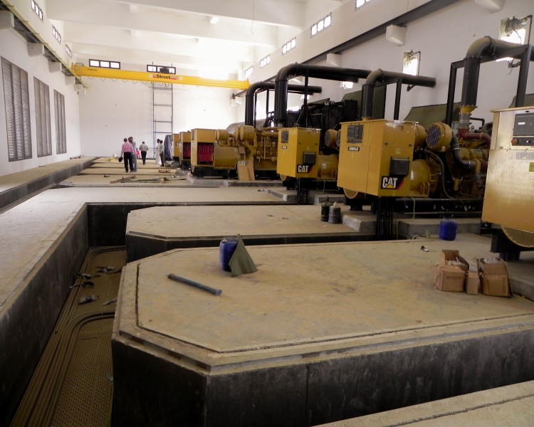
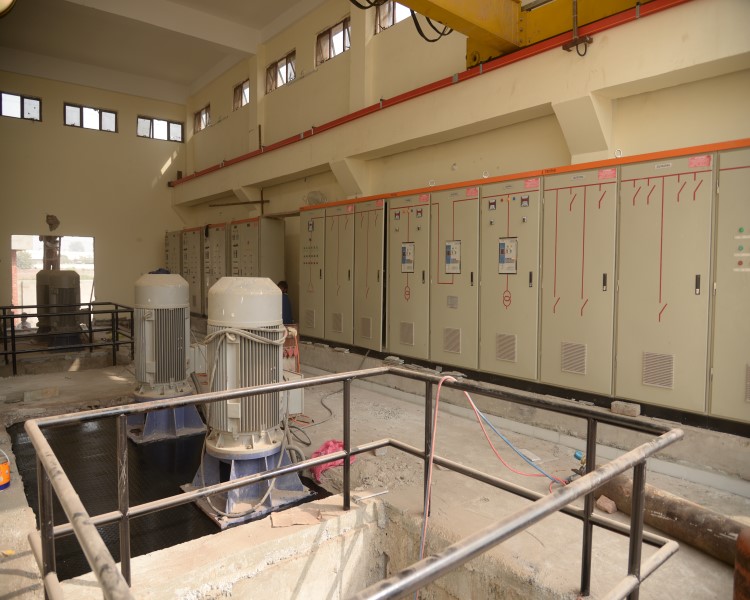
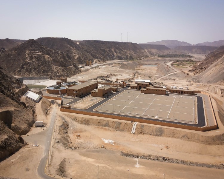
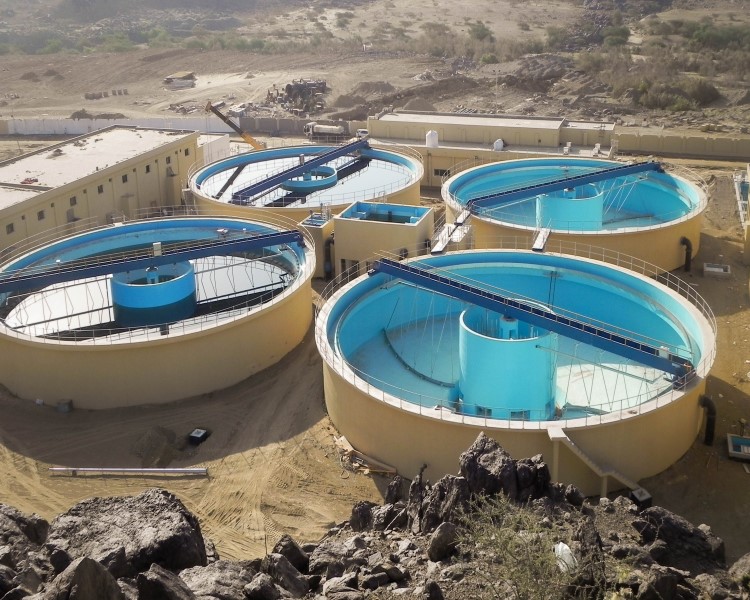
10 industrial wastes management projects comprising waste water collection, treatment and disposal systems, wastewater treatment plants for tanneries, pulp and paper mills, reclamation of wastewater, procurement, inspection, installation of treatment plants along with their related electrical and mechanical equipment.
 Line, Khulais, Kingdom of Saudi Arabia.jpg)